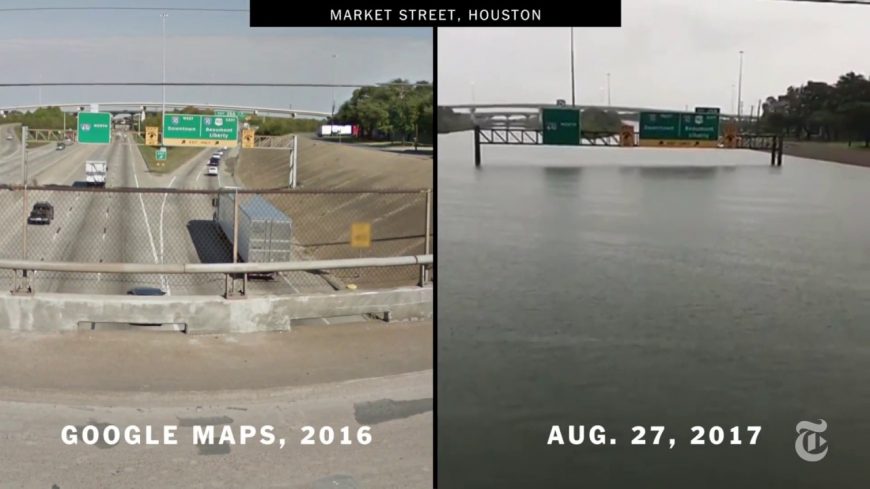
Check Out The Houston Roadways Before and After Hurricane Harvey!

Hurricane Harvey has absolutely ravaged the city of Houston, Texas. After battering the city with 100+ MPH winds when it made landfall, the storm has basically been thrown into neutral, churning in place and dumping some estimated 15 trillion gallons of water on the city and surrounding communities, with another 5 trillion gallons expected to fall before the storm finally dissipates. To put that into perspective, Hurricane Katrina, which decimated New Orleans on this date back in 2005, was estimated to have dropped about 6.5 trillion gallons, or roughly one third of Harvey’s expected rainfall.

FEMA has already noted that they expect to be in the Houston area for many years to come while the city dries itself and begins the long recovery process. This has been called a “once-in-a-thousand-years” level event that hopefully none of us ever see the likes of again. According to forecasters, a frontal boundary moved across the Lone Star state just ahead of the hurricane making landfall, leaving nothing to push the storm out of the area after it came ashore, therefore leaving it stuck almost directly above Houston.

As you can see in the video below, there are some areas that you would never believe are roadways, because they look quite simply like huge lakes. Were it not for the side-by-side Google Maps comparison, these areas would not be identifiable. Area’s that just last week were some of the busiest highways in the state are now just vast expanses of water. In some areas, the water has reached and covered rooftops, and countless people have lost everything they ever owned.

One positive outcome, at least at this point in time, is that there hasn’t been a large number of lives lost. While any loss is tragic, a storm like this could have wiped out much of the population of Houston if advanced warning hadn’t been given.

